


Droneradar
Opis Droneradar
The application meets the requirements set out in the EC Delegated Regulation 2019/945 and Implementing Regulation 2019/947 as well as the provisions set out by the Polish Air Navigation Services Agency.
Droneradar is an official application enabling drone operators to find their way in the complicated maze of aviation regulations. The application is integrated with PansaUTM administered by the Polish Air Navigation Services Agency. The application is supported by the Polish Civil Aviation Office (ULC).
!!! REMEMBER TO FOLLOW TIPS provided by Air Traffic Services!!!
!!! Please be sure, you enable notifications !!!
!!! Turn on location service on your phone during application installation !!!
Congratulations on purchasing your new unmanned aircraft, often called drone, RPAS, UAV, or BSP.
With the first flight, you will join the group of airspace users. Despite its small size, your unmanned aerial vehicle is an aircraft with all its associated consequences.
The most important rules of unmanned aerial vehicle movement:
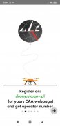
- If you are flying a drone over 250gr. or any drone with a camera, register at drony.ulc.gov.pl or on the Webpage of your CAA (Civil Aviation Authority). Enter the received Drone Operator Registration number in the Droneradar application during flight Check-In.
- Obey the rules. The iconographic images in the application illustrate what you can and what you cannot. Check their meaning out on the droneradar.eu
- Minimise the risk associated with a possible failure of your drone
- Be mind always "in front of the drone". Don't let the drone get ahead of your intentions
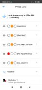
- Never fly near airports (the lights in the application will tell you how close you are to the airport and whether you can fly your unmanned aerial vehicle);
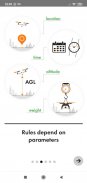
- Fly in sight;
- Do not fly higher than 120 m. (approx. 450 ft) AGL (Above Ground Level) in Open category. AGL stands for Over Terrain. 150 m. AGL is the minimum altitude for manned aircraft. They may not notice your drone;
- Although it is not compulsory, buy liability insurance
Are these rules enough to fly safely? Not always! You must be aware of existing air structures.
Using the Droneradar application, you can quickly and easily check if you can fly in a given place and time. Droneradar will inform you about other space users.
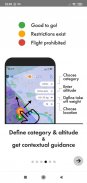
How does Droneradar work?
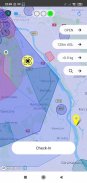
Run the application, allow location services and observe the color of the lights at the top of the screen.
GREEN - you can fly with attention to the height declared in the application.
YELLOW - there are restrictions. You can check them by clicking the signaller icon at the top of the screen. There you will find a phone number for airspace managers.
RED - no flights.
Check-In flight location registration
To inform other space users about your flights, click the Check-In. Enter your contact details and the type of drone you control. This information is voluntary, so it is worth it to be true. Confirm location. Your flying are will be marked on the Droneradar map for the indicated time.
If a flight plan is required at the selected location, log in to PansaUTM at https://utm.pansa.pl and follow the instructions.
Safe and fun flights!
Droneradar team
dlapilota.pl / droneradar Sp. z o.o. the creator of the application and reserves the right to disable the service and / or update it at any time.
Droneradar - Wersja 2.0.899
(02-02-2021)Droneradar - Informacje APK
Wersja APK: 2.0.899Pakiet: eu.droneradar.droneradarNajnowsza wersja Droneradar
Inne wersje


Apki w tej samej kategorii


